Google
 

16 November 2008

Sparrow Hills, Moscow, Russia

Location (via Google Maps): Sparrow Hills, Moscow, Russia

Coordinates: 55° 42' 53" N, 37° 32' 50" E. Find With Google Earth.

Sparrow Hills, Moscow, Russia

Sparrow Hills is a hill on the right bank of the Moscow River and one of highest points in Moscow with an altitude up to 220 m (60–70 m above the river level).

The observation platform, which gives a good panoramic view of the city, is situated on a steep bank 85 m above the river (200 m above the sea level). The Luzhniki Stadium, where the opening and closing ceremony for the 1980 Summer Olympics took place, is right below across the Moskva River. Learn more...

The places on the view from above marked with the numbers are:

  1. The observation platform.
  2. The Moscow State University.
  3. The Luzhniki Stadium.

The Observation Platform at Sparrow Hills, Moscow, Russia

The Moscow State University, Moscow, Russia

View of The Luzhniki Stadium from the Observation Platform at Sparrow Hills, Moscow, Russia

Bolshoi Theatre, Moscow, Russia

Location (via Google Maps): Bolshoi Theatre, Moscow, Russia

Coordinates: 55° 45' 37" N, 37° 37' 7" E. Find With Google Earth.

Bolshoi Theatre, Moscow, Russia

The Bolshoi Theatre (Great Theatre) is a historic theatre in Moscow, Russia, designed by famed architect Joseph Bove, which holds performances of ballet and opera. The Bolshoi Ballet and Bolshoi Opera are each one of the oldest and greatest ballet and o pera companies of the world, respectively. The Theatre is the parent company of The Bolshoi Ballet Academy, a world-leading school of ballet. Learn more...

08 November 2008

The Cathedral of Christ the Saviour, Moscow, Russia

Location (via Google Maps): The Cathedral of Christ the Saviour, Moscow, Russia

Coordinates: 55° 44' 40" N, 37° 36' 20" E. Find With Google Earth.

The Cathedral of Christ the Saviour, Moscow, Russia

The Cathedral of Christ the Saviour is the tallest Eastern Orthodox Church in the world. It is situated in Moscow, on the bank of the Moskva River, a few blocks west of the Kremlin.

When the last of Napoleon's soldiers left Moscow, Tsar Alexander I signed a manifesto, December 25, 1812, declaring his intention to build a Cathedral in honor of Christ the Saviour "to signify Our gratitude to Divine Providence for saving Russia from the doom that overshadowed Her" and as a memorial to the sacrifices of the Russian people.

The Cathedral had taken many years to build. It was consecrated on May 26, 1883.

After the Revolution and, more specifically, the death of Lenin, the prominent site of the cathedral was chosen by the Soviets as the site for a monument to socialism known as the Palace of Soviets. On December 5, 1931, by order of Stalin's minister Kaganovich, the Cathedral of Christ the Saviour was dynamited and reduced to rubble.

The Cathedral of Christ the Saviour, Moscow, Russia

With the end of the Soviet rule, the Russian Orthodox Church received permission to rebuild the Cathedral of Christ the Saviour in February 1990. A temporary cornerstone was laid by the end of the year. The lower church was consecrated to the Saviour's Transfiguration in 1996, and the completed Cathedral of Christ the Saviour was consecrated on the Transfiguration day, August 19, 2000. Learn more...

The Moscow Kremlin, Moscow, Russia

Location (via Google Maps): The Moscow Kremlin, Moscow, Russia

Coordinates: 55° 45' 6" N, 37° 37' 4" E. Find With Google Earth.

The Moscow Kremlin, Moscow, Russia


Moscow is the capital and the largest city of Russia.

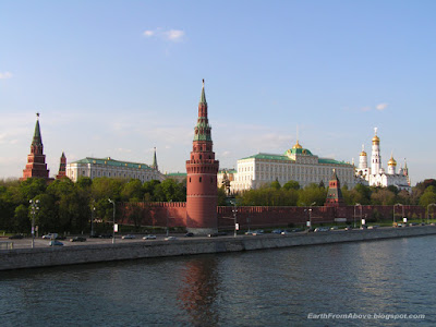
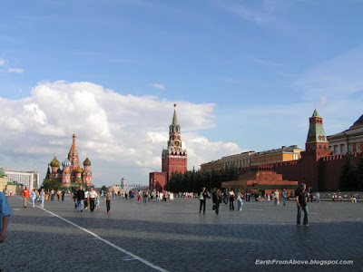
The Moscow Kremlin usually referred to as simply The Kremlin, is a historic fortified complex at the heart of Moscow, overlooking the Moskva River (to the south), Saint Basil's Cathedral and Red Square (to the east) and the Alexander Garden (to the west). It includes four palaces, four cathedrals, and the enclosing Kremlin Wall with Kremlin towers. The complex serves as the official residence of the President of Russia. Learn more...

The places on the view from above marked with the numbers are:

  1. The Moscow Kremlin.
  2. The Red Square.
  3. Saint Basil's Cathedral.
  4. The State Historical Museum of Russia.
  5. The Main Department Store.
  6. The Alexander Garden.
  7. The Moskva River.

View of the Moscow Kremlin from Bolshoy Kamenny Bridge, Moscow, Russia

The Red Square with Saint Basil's Cathedral, Moscow, Russia

Terem Churches in the Moscow Kremlin, Moscow, Russia

The Fortezza Castle, Rethymno, Crete, Greece

Coordinates: 35° 22' 0" N, 24° 28' 0" E. Find With Google Earth.

Fortezza Castle, Rethymno, Crete, Greece

Fortezza Castle is a museum and Venetian castle in Rethymno, Greece. It is the one of the biggest and best standing castles in Crete. Learn more...

Inside Fortezza Castle, Rethymno, Crete, Greece

The Old Venetian Port, Rethymno, Crete, Greece

Coordinates: 35° 22' 0" N, 24° 28' 0" E. Find With Google Earth.

The Old Venetian Port, Rethymno, Crete, Greece

Rethymno (also Rethimno, Rethymnon, Rethymnon, and Rhithymnos) is the capital of Rethymno Prefecture in the island of Crete.

Today's old town (palia poli) is almost entirely built by Venetians. It is one of the best preserved old towns in Crete. The town still maintains its old aristocratic appearance, with its buildings dating from the 16th century, arched doorways, stone staircases, Byzantine and Hellenic-Roman remains, small Venetian harbor and narrow streets. Learn more...


The Old Venetian Port, Rethymno, Crete, Greece

31 August 2008

The Island of Spinalonga, Greece

Coordinates: 35° 16' 20" N, 25° 44' 55" E. Find With Google Earth.

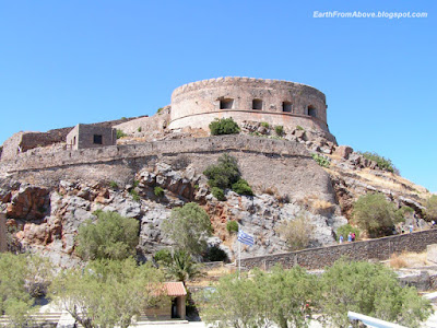
The Island of Spinalonga from above

The island of Spinalonga (official name: Kalidon) is located at the eastern section of Crete, near the town of Elounda. The name of the island, Spinalonga, is Venetian, meaning "long thorn", and has roots in the period of Venetian occupation.

The Island of Spinalonga

The Spinalonga fortress was built by the Venetians in XVIth century. In 1579, the General Previsor of Crete Luca Michiel put the foundation stone of the fortifications. Following the Turkish occupation of Crete in 1669, only the fortresses of Gramvousa , Souda and Spinalonga remained in Venetian hands. The Venetians kept control of the island until the Ottoman Empire took possession of it in 1715.

The Spinalonga Fortress

The island was subsequently used as a leper colony, from 1903 to 1957. It is notable for being one of the last active leper colonies in Europe.

Today, the unoccupied island is one of the main tourist attractions in Crete. In addition to the abandoned leper colony and the fortress, Spinalonga is known for its small pebble beaches. The island can easily be accessed from Elounda and Agios Nikolaos. Tourist boats depart from both towns on a daily basis. Learn more...

28 August 2008

Lake Voulismeni, Agios Nikolaos, Crete, Greece

Coordinates: 35° 11' 26" N, 25° 43' 2" E. Find With Google Earth.

Lake Voulismeni from Above, Agios Nikolaos, Crete, Greece

Lake Voulismeni (Limni Voulismeni) is a former sweetwater small lake, later connected to the sea, located at the centre of the town of Agios Nikolaos on the Greek island of Crete It has a circular shape of a diameter of 137 m and depth 64 m. The locals refer to it as just "the lake". The lake connects to the harbour of the town by a channel dug in 1870. A panoramic view of the lake can be seen from a small park situated above it.

According to legend, the goddess Athena bathed in it. Every year at midnight turning to Orthodox Christian Easter day, the majority of the population of the town gathers around the lake to celebrate with fireworks, and firecrackers thrown by the people attending that highlight event.

It was reported that the German army during their withdrawal from the area at WW2, disposed parts of their weaponry and/or vehicles into the deep lake.

A local urban legend has it that the lake is bottomless. That notion is potentially based on its impressively disproportional high depth compared to its width or/and on locals noticing disturbances at the surface or also the level of the water during the Santorini (Thera) earthquake of 1956. Because of the latter, many assume a possible geological relation of the two locations, but this claim has not been substantiated by known scientific surveys to date.

Source: en.wikipedia.org.

Lake Voulismeni, Agios Nikolaos, Crete, Greece

27 August 2008

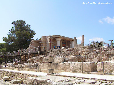
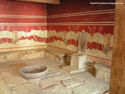
Knossos, Crete, Greece

Coordinates: 35° 17' 52.66" N, 25° 9' 47.36" E. Find With Google Earth.

Ruins of the Minoan palace at Knossos, Crete, Greece

Knossos (alternative spellings Knossus, Cnossus, Gnossus), is the largest Bronze Age archaeological site on Crete and probably the ceremonial and political center of the Minoan civilization and culture. It is also a tourist destination today, as it is near the main city of Heraklion and has been substantially, if imaginatively "restored", making the site more comprehensible to the visitor than a field of unmarked ruins.

The city of Knossos remained important through the Classical and Roman periods, but its population shifted to the new town of Handaq (modern Heraklion) during the 9th century AD. By the 13th century, it was called Makryteikhos 'Long Wall'; the bishops of Gortyn continued to call themselves Bishops of Knossos until the 19th century.[1] Today, the name is used only for the archaeological site situated in the suburbs of Heraklion. Learn more...

Ruins of the Minoan palace at Knossos, Crete, Greece

Bastion A at the North Entrance, the Minoan palace at Knossos, Crete, Greece

Ruins of the Minoan palace at Knossos, Crete, Greece

Throne Room, the Minoan palace at Knossos, Crete, Greece

Cathedral of St. Minas, Heraklion, Crete, Greece

Coordinates: 35° 20' 15.69" N, 25° 7' 52.01" E.


Cathedral of St. Minas, Heraklion, Crete, Greece

The Cathedral and of Saint Minas is the large and impressive church, situated on Saint Catherine square, in the town of Heraklion. It is one of the largest cathedrals in Greece.

Cathedral of St. Minas, Heraklion, Crete, Greece

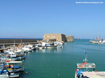
Venetian Medieval Fortress Rocca al Mare at the Harbour of Heraklion, Crete, Greece

Coordinates: 35° 20' 0" N, 25° 8' 0" E. Find With Google Earth.

Venetian Medieval Fortress Rocca al Mare at the Harbour of Heraklion, Crete, Greece

Heraklion or Iraklion is the largest city and capital of Crete. It is also the fourth largest city in Greece. For centuries Heraklion was known as Candia.

The biggest monument of the city is the Venetian medieval fortress Rocca al Mare (also known as Koules, Turkish for "tower") located at the port. Learn more...

Venetian Medieval Fortress Rocca al Mare at the Harbour of Heraklion, Crete, Greece

Venetian Medieval Fortress Rocca al Mare at the Harbour of Heraklion, Crete, Greece

31 July 2008

Palace of the Grand Master of the Knights of Rhodes, Greece

Palace of the Grand Master of the Knights of Rhodes, Greece

The Palace of the Grand Master of the Knights of Rhodes is a palace in the town of Rhodes, on the island of Rhodes in Greece. The palace was built in the 14th century by the Knights of Rhodes (now officially known as the Sovereign Military Hospitaller Order of St. John of Jerusalem, of Rhodes, and of Malta), who occupied Rhodes from 1309 to 1522. After the island was captured by the Ottoman Empire, the palace was used as a fortress.

The original palace was largely destroyed by an ammunition explosion in 1856. When the Kingdom of Italy occupied Rhodes in 1912, the Italians rebuilt the palace in a grandiose pseudo-medieval style as a holiday residence for Victor Emmanuel III of Italy, and later for Benito Mussolini, whose name can still be seen on a large plaque near the entrance.

On 10 February 1947, the Treaty of Peace with Italy, one of the Paris Peace Treaties, determined than the recently-established Italian Republic would transfer the Dodecanese the Kingdom of Greece. In 1948, Rhodes and the rest of the Dodecanese were transfered as previously agreed. The Greeks converted the palace to a museum. Learn more...

Rhodes, The Island Of Rhodes, Greece

Coordinates: 36° 26' 0" N, 28° 13' 0" E. Find With Google Earth.

Rhodes, The Island Of Rhodes, Greece

Rhodes is the principal city of the Greek island of Rhodes, in southeastern Aegean Sea and the capital of the Dodecanese prefecture. Rhodes has been famous since antiquity as the site of Colossus of Rhodes, one of the Seven Wonders of the World. The citadel of Rhodes, built by the Hospitalliers, is one of the best preserved medieval towns in Europe which in 1988 was designated as a UNESCO World Heritage Site. The City of Rhodes is a popular international tourist destination. Learn more...

20 May 2008

Santa Maria della Salute, Venice, Italy

Coordinates: 45° 25' 51" N, 12° 20' 4" E. Find With Google Earth.

Santa Maria della Salute, Venice, Italy

The Basilica di Santa Maria della Salute (Basilica of St Mary of Health/Salvation), commonly known simply as the Salute, is a famous church in Venice, placed scenically at a narrow finger of land which lies between the Grand Canal and the Bacino di San Marco on the lagoon, visible as one enters the Piazza San Marco from the water. While it has the status of a minor basilica, its decorative and distinctive profile and location make it among the most photographed churches in Italy. Learn more...

Piazza San Marco, Venice, Italy

Coordinates: 45° 26' 2.4" N, 12° 20' 16.8" E. Find With Google Earth.

Piazza San Marco, Venice, Italy

Piazza San Marco, often known in English as St Mark's Square, is the principal square of Venice, Italy.

A remark often attributed to Napoleon (but perhaps more correctly to Alfred de Musset) calls the Piazza San Marco "The drawing room of europe". It is one of the few great urban spaces in a Europe where human voices prevail over the sounds of motorized traffic, which is confined to Venice's waterways. It is the only urban space called a piazza in Venice; the others, regardless of size, are called campi.

As the central landmark and gathering place for Venice, Piazza San Marco is extremely popular with tourists, photographers, and Venetian pigeons.

The Piazza originated in the 9th century as a small area in front of the original St Mark's Basilica. It was enlarged to its present size and shape in 1177, when the Rio Batario, which had bounded it to the west, and a dock, which had isolated the Doge's Palace from the square, were filled in. The rearrangement was for the meeting of Pope Alexander III and the Emperor Frederick Barbarossa.

The Piazza has always been seen as the centre of Venice. It was the location of all the important offices of the Venetian state, and has been the seat of the archbishopric since the 19th century. It was also the focus for many of Venice's festivals. It is a greatly popular place in Italy even today. Learn more...

Venice, Italy

Coordinates: 45° 26' 0" N, 12° 19' 0" E. Find With Google Earth.

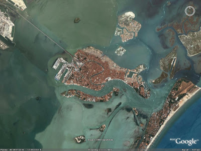
Venice, Italy

Venice, Italy

Venice (Italian: Venezia, Venetian: Venezsia) is a city in northern Italy, the capital of region Veneto, and has a population of 271,251 (census estimate January 1, 2004). Together with Padua, the city is included in the Padua-Venice Metropolitan Area (population 1,600,000). Venice has been known as the "La Dominante", "Serenissima", "Queen of the Adriatic", "City of Water", "City of Bridges", and "The City of Light". It is considered by many one of the more beautiful cities in the world.

The city stretches across 118 small islands in the marshy Venetian Lagoon along the Adriatic Sea in northeast Italy. The saltwater lagoon stretches along the shoreline between the mouths of the Po (south) and the Piave (north) Rivers. The population estimate of 272,000 inhabitants includes the population of the whole Comune of Venezia; around 62,000 in the historic city of Venice (Centro storico); 176,000 in Terraferma (the Mainland), mostly in the large frazione of Mestre and Marghera; and 31,000 live on other islands in the lagoon. Learn more...

15 April 2008

Mount Vesuvius, Italy

Coordinates: 40° 49' 14" N, 14° 25' 47" E. Find With Google Earth.

Mount Vesuvius, Italy

Mount Vesuvius (Italian: Monte Vesuvio, Latin: Mons Vesuvius) is an active stratovolcano east of Naples, Italy. It is the only volcano on the European mainland to have erupted within the last hundred years, although it is not currently erupting.

Vesuvius is best known for its eruption in AD 79 that led to the destruction of the Roman cities of Pompeii and Herculaneum. It has erupted many times since and is today regarded as one of the most dangerous volcanoes in the world because of the population of 3,000,000 people now living close to it and its tendency towards explosive eruptions. It is the most densely populated volcanic region in the world. Learn more...

14 April 2008

Vatican Museums

Vatican MuseumsThe Vatican Museums (Italian: Musei Vaticani) are the public art and sculpture museums in the Vatican City, which display works from the extensive collection of the Roman Catholic Church. Pope Julius II founded the museums in the 16th century. The Sistine Chapel and the Stanze della Segnatura decorated by Raphael are on the visitor route through the Vatican Museums. As of November 2006, it was visited by more than 4,000,000 people for the year. Learn more...

13 April 2008

St. Peter's Basilica and Saint Peter's Square, Vatican

Coordinates: 41° 54' 8" N, 12° 27' 23" E. Find With Google Earth.

St. Peter's Basilica and Saint Peter's Square, Vatican

The Basilica of Saint Peter (Latin: Basilica Sancti Petri), officially known in Italian as the Basilica di San Pietro in Vaticano and commonly called Saint Peter's Basilica, is one of four major basilicas of Rome (Basilica of St. John Lateran, St. Peter's, Santa Maria Maggiore and St. Paul outside the Walls). It is the most prominent building inside the Vatican City and built on the ruins of Old Saint Peter's Basilica. Its dome is also a dominant feature of the Roman skyline. Saint Peter's is also incidentally the patriarchal basilica of Constantinople, whereas the Lateran Basilica is the patriarchal basilica of Rome. Possibly the largest church building in Christianity[1], it covers an area of 2.3 ha (5.7 acres) and has a capacity of over 60,000 people. Learn more...


Saint Peter's Square, or Saint Peter's Piazza (Italian: Piazza San Pietro), is located directly in front of St. Peter's Basilica. Learn more...

12 April 2008

Basilica di Santa Maria Maggiore, Rome, Italy

Coordinates: 41° 53' 51" N, 12° 29' 55" E. Find With Google Earth.

Basilica di Santa Maria Maggiore, Rome, Italy

The Basilica di Santa Maria Maggiore (its Italian name), known in English also as St Mary Major, is an ancient Catholic basilica of Rome. It is one of the four major or four papal basilicas, which, together with St. Lawrence outside the Walls, were formerly referred to as the five "patriarchal basilicas" of Rome, associated with the five ancient patriarchal sees of Christendom (see Pentarchy). The other three papal or major basilicas are St. John Lateran, St. Peter and St. Paul outside the Walls. The Liberian Basilica (another title for the church) is one of the tituli, presided over by a patron—in this case Pope Liberius—that housed the major congregations of early Christians in Rome. Santa Maria Maggiore is the only Roman basilica that retained the core of its original structure, left intact despite several additional construction projects and damage from the earthquake of 1348. Learn more...

Santo Stefano Rotondo, Rome, Italy

Coordinates: 41° 53' 4" N, 12° 29' 48" E. Find With Google Earth.

Santo Stefano Rotondo, Rome, Italy

Santo Stefano Rotondo, also known as Santo Stefano al Monte Celio, is an ancient basilica church in Rome. It lies on the Caelian Hill.

The edifice was consecrated by Pope Simplicius between 468 and 483. It was dedicated to protomartyr Saint Stephen, whose body had been discovered a few decades before in the Holy Land, and brought into Rome. The church was the first in Rome to have a circular plan, inspired by the Church of the Holy Sepulchre in Jerusalem. Learn more...

Santa Maria in Trastevere, Rome, Italy

Coordinates: 41° 53' 22" N, 12° 28' 11" E. Find With Google Earth.

Santa Maria in Trastevere, Rome, Italy

The basilica of Santa Maria in Trastevere is one of the oldest churches in Rome, perhaps the first in which mass was openly celebrated. This is the queen of the trasteverine churches. The inscription on the episcopal chair says that it is the first church dedicated to the Mother of God, although actually that privilege belongs to Basilica di Santa Maria Maggiore. It is certainly one of the oldest churches in the City. A Christian house-church was founded here about 220 by Pope St. Callixtus I (217-222) on the site of the Taberna meritoria, an asylum for retired soldiers. The area was given over to Christian use by the Emperor Severus when he settled a dispute between the Christians and tavern-keepers, saying, "I prefer that it should belong to those who honor God, whatever be their form of worship." In 340 Pope Julius I (337-352) rebuilt the titulus Callixti on a larger scale, and it became the titulus Iulii, one of the original twenty-five parishes in Rome, and indeed may be the first church in which Mass was celebrated openly. It underwent two restorations in the fifth and eighth centuries, and in 1140 it was re-erected under Innocent II as a thanksgiving offering for the submission of the anti-pope, Celestine II (1124). It was rebuilt in the 12th century. Learn more...
11 April 2008

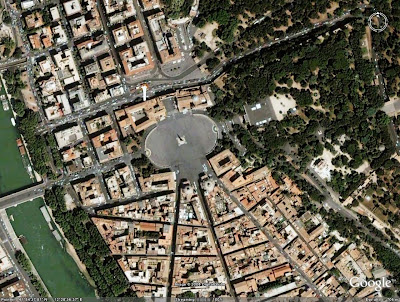
Piazza del Popolo, Rome, Italy

Coordinates: 41° 54' 38" N, 12° 28' 35" E. Find With Google Earth.

Piazza del Popolo, Rome, Italy

The Piazza del Popolo is a square in Rome. The name in modern Italian literally means "piazza of the people", but historically it derives from the poplars (populus in Latin, pioppo in Italian) after which the church of Santa Maria del Popolo, in the northeast corner of the piazza, takes its name.

The Piazza lies inside the northern gate in the Aurelian Walls, once the Porta Flaminia of ancient Rome, and now called Porta del Popolo. This was the starting point of the Via Flaminia, the road to Ariminum (modern Rimini) and the most important route to the north. At the same time, before the age of railroads, it was the traveller's first view of Rome upon arrival. For centuries, the Piazza del Popolo was a place for public executions, the last of which took place in 1826. Learn more...
Piazza Navona, Rome, Italy

Coordinates: 41° 53' 56" N, 12° 28' 23" E. Find With Google Earth.

Piazza Navona, Rome, Italy

Piazza Navona is a square in Rome, Italy. The piazza follows the plan of an ancient Roman circus, the 1st century Stadium of Domitian, where the Romans came to watch the agones ("games"): It was known as 'Circus Agonalis' (competition arena). It is believed that over time the name changed to 'in agone' to 'navone' and eventually to 'navona'.

Defined as a square in the last years of 15th century, when the city market was transferred here from the Campidoglio, Piazza Navona is now the pride of Baroque Rome. It has sculptural and architectural creations: by Gian Lorenzo Bernini, the famous Fontana dei Quattro Fiumi (Fountain of the Four Rivers, 1651) in the center; by Francesco Borromini and Girolamo Rainaldi, the church of Sant'Agnese in Agone; and by Pietro da Cortona, who painted the gallery in the Pamphilj palace. Learn more...

10 April 2008

Quirinal Palace, Rome, Italy

Coordinates: 41° 54' 0" N, 12° 29' 12.85" E. Find With Google Earth.

Quirinal Palace, Rome, Italy

The Quirinal Palace (known in Italian as the Palazzo del Quirinale or simply the Quirinale) is the official residence of the President of the Italian Republic upon the Quirinal Hill, the tallest of the seven hills of Rome.

The palace, located on the Via del Quirinale and facing onto the Piazza del Quirinale, was built in 1573 by Pope Gregory XIII as a papal summer residence. It was also used as the location for many papal conclaves. It served as a papal residence and housed the central offices responsible for the civil government of the Papal States until 1870. In September, 1870, what was left of the Papal States was overthrown. About five months later, in 1871, Rome became the capital of the new Kingdom of Italy. The palace was occupied during the invasion of Rome and became the official royal residence of the Kings of Italy, though in reality some monarchs, notably King Victor Emmanuel III (reigned 1900-1946) actually lived in a private residence elsewhere, the Quirinale being used simply as an office and for state functions. The monarchy was abolished in 1946 and the Palace became the official residence and workplace for the Presidents of the Italian Republic. Learn more...

09 April 2008

Palazzo Montecitorio, Rome, Italy

Coordinates: 41° 54' 5" N, 12° 28' 43" E. Find With Google Earth.

Palazzo Montecitorio, Rome, Italy

The Palazzo Montecitorio is a palace in Rome, which is currently the seat of the Italian Chamber of Deputies.

The building was originally designed by Gian Lorenzo Bernini for the young Cardinal Ludovisi, nephew of Pope Gregory XV. However, with the death of Gregory XV by 1623, work stopped, and was not restarted until the papacy of pope Innocent X, when it was completed by the architect Carlo Fontana, who modified Bernini's plan with the addition of a bell gable above the main entrance. Learn more...

07 April 2008

Monument to Vittorio Emanuele II, Rome, Italy

Coordinates: 41° 53' 40.55" N, 12° 28' 59.13" E. Find With Google Earth.

Monument to Vittorio Emanuele II, Rome, Italy

The Monumento Nazionale a Vittorio Emanuele II (National Monument of Victor Emmanuel II) or Altare della Patria (Altar of the Fatherland) or "Il Vittoriano" is a monument to honour Victor Emmanuel, the first king of a unified Italy. It is located in Rome, Italy. It occupies a site between the Piazza Venezia and the Capitoline Hill. The monument was designed by Giuseppe Sacconi in 1895; sculpture for it was parceled out to established sculptors all over Italy. It was inaugurated in 1911 and completed in 1935. Learn more...
Basilica of Saint Paul Outside the Walls, Rome, Italy

Coordinates: 41° 51' 31" N, 12° 28' 38" E. Find With Google Earth.

Basilica of Saint Paul Outside the Walls, Rome, Italy

Basilica di San Paolo fuori le Mura — known in English as the Basilica of St Paul Outside the Walls or St Paul-without-the-Walls — is one of four churches considered to be the great ancient basilicas of Rome. The Roman Catholic Church counts among them St. John Lateran, St. Mary Major, and St. Peter's. Cardinal Andrea Cordero Lanza di Montezemolo, named in 2005, is the current archpriest of this basilica. Learn more...

26 March 2008

Mausoleum of Augustus, Rome, Italy

Coordinates: 41° 54' 22" N, 12° 28' 35" E. Find With Google Earth.

The Mausoleum of Augustus was a large tomb built by the Roman Emperor Augustus in 28 BC on the Campus Martius in Rome. The Mausoleum, now located on the Piazza Augusto Imperatore, is no longer open to tourists, and the ravages of time and carelessness have stripped the ruins bare. However, the ruins remain an impressive and dominating landmark on the northern side of the Campus Martius.

The Mausoleum was one of the first projects initiated by Augustus in the city of Rome following his victory at the Battle of Actium in 31 BC. The mausoleum was circular in plan, consisting of several concentric rings of earth and brick, planted with cypresses and capped (possibly, as reconstructions are unsure at best) by a conical roof and a statue of Augustus. Vaults held up the roof and opened up the burial spaces below. Twin pink granite obelisks flanked the arched entryway; these now stand, one at the Piazza dell'Esquilino (on the northwest side of the Basilica of Santa Maria Maggiore) and other at the Quirinal fountain. The completed Mausoleum measured 90 m (295 ft) in diameter by 42 m (137 ft) in height. Learn more...

Italy From Above

Ancient Italy from Above

Rome (Italy from Above)

Sea of Italy (Italy from Above)