Google
 

15 April 2008

Mount Vesuvius, Italy

Coordinates: 40° 49' 14" N, 14° 25' 47" E. Find With Google Earth.

Mount Vesuvius, Italy

Mount Vesuvius (Italian: Monte Vesuvio, Latin: Mons Vesuvius) is an active stratovolcano east of Naples, Italy. It is the only volcano on the European mainland to have erupted within the last hundred years, although it is not currently erupting.

Vesuvius is best known for its eruption in AD 79 that led to the destruction of the Roman cities of Pompeii and Herculaneum. It has erupted many times since and is today regarded as one of the most dangerous volcanoes in the world because of the population of 3,000,000 people now living close to it and its tendency towards explosive eruptions. It is the most densely populated volcanic region in the world. Learn more...

14 April 2008

Vatican Museums

Vatican MuseumsThe Vatican Museums (Italian: Musei Vaticani) are the public art and sculpture museums in the Vatican City, which display works from the extensive collection of the Roman Catholic Church. Pope Julius II founded the museums in the 16th century. The Sistine Chapel and the Stanze della Segnatura decorated by Raphael are on the visitor route through the Vatican Museums. As of November 2006, it was visited by more than 4,000,000 people for the year. Learn more...

13 April 2008

St. Peter's Basilica and Saint Peter's Square, Vatican

Coordinates: 41° 54' 8" N, 12° 27' 23" E. Find With Google Earth.

St. Peter's Basilica and Saint Peter's Square, Vatican

The Basilica of Saint Peter (Latin: Basilica Sancti Petri), officially known in Italian as the Basilica di San Pietro in Vaticano and commonly called Saint Peter's Basilica, is one of four major basilicas of Rome (Basilica of St. John Lateran, St. Peter's, Santa Maria Maggiore and St. Paul outside the Walls). It is the most prominent building inside the Vatican City and built on the ruins of Old Saint Peter's Basilica. Its dome is also a dominant feature of the Roman skyline. Saint Peter's is also incidentally the patriarchal basilica of Constantinople, whereas the Lateran Basilica is the patriarchal basilica of Rome. Possibly the largest church building in Christianity[1], it covers an area of 2.3 ha (5.7 acres) and has a capacity of over 60,000 people. Learn more...


Saint Peter's Square, or Saint Peter's Piazza (Italian: Piazza San Pietro), is located directly in front of St. Peter's Basilica. Learn more...

12 April 2008

Basilica di Santa Maria Maggiore, Rome, Italy

Coordinates: 41° 53' 51" N, 12° 29' 55" E. Find With Google Earth.

Basilica di Santa Maria Maggiore, Rome, Italy

The Basilica di Santa Maria Maggiore (its Italian name), known in English also as St Mary Major, is an ancient Catholic basilica of Rome. It is one of the four major or four papal basilicas, which, together with St. Lawrence outside the Walls, were formerly referred to as the five "patriarchal basilicas" of Rome, associated with the five ancient patriarchal sees of Christendom (see Pentarchy). The other three papal or major basilicas are St. John Lateran, St. Peter and St. Paul outside the Walls. The Liberian Basilica (another title for the church) is one of the tituli, presided over by a patron—in this case Pope Liberius—that housed the major congregations of early Christians in Rome. Santa Maria Maggiore is the only Roman basilica that retained the core of its original structure, left intact despite several additional construction projects and damage from the earthquake of 1348. Learn more...

Santo Stefano Rotondo, Rome, Italy

Coordinates: 41° 53' 4" N, 12° 29' 48" E. Find With Google Earth.

Santo Stefano Rotondo, Rome, Italy

Santo Stefano Rotondo, also known as Santo Stefano al Monte Celio, is an ancient basilica church in Rome. It lies on the Caelian Hill.

The edifice was consecrated by Pope Simplicius between 468 and 483. It was dedicated to protomartyr Saint Stephen, whose body had been discovered a few decades before in the Holy Land, and brought into Rome. The church was the first in Rome to have a circular plan, inspired by the Church of the Holy Sepulchre in Jerusalem. Learn more...

Santa Maria in Trastevere, Rome, Italy

Coordinates: 41° 53' 22" N, 12° 28' 11" E. Find With Google Earth.

Santa Maria in Trastevere, Rome, Italy

The basilica of Santa Maria in Trastevere is one of the oldest churches in Rome, perhaps the first in which mass was openly celebrated. This is the queen of the trasteverine churches. The inscription on the episcopal chair says that it is the first church dedicated to the Mother of God, although actually that privilege belongs to Basilica di Santa Maria Maggiore. It is certainly one of the oldest churches in the City. A Christian house-church was founded here about 220 by Pope St. Callixtus I (217-222) on the site of the Taberna meritoria, an asylum for retired soldiers. The area was given over to Christian use by the Emperor Severus when he settled a dispute between the Christians and tavern-keepers, saying, "I prefer that it should belong to those who honor God, whatever be their form of worship." In 340 Pope Julius I (337-352) rebuilt the titulus Callixti on a larger scale, and it became the titulus Iulii, one of the original twenty-five parishes in Rome, and indeed may be the first church in which Mass was celebrated openly. It underwent two restorations in the fifth and eighth centuries, and in 1140 it was re-erected under Innocent II as a thanksgiving offering for the submission of the anti-pope, Celestine II (1124). It was rebuilt in the 12th century. Learn more...

11 April 2008

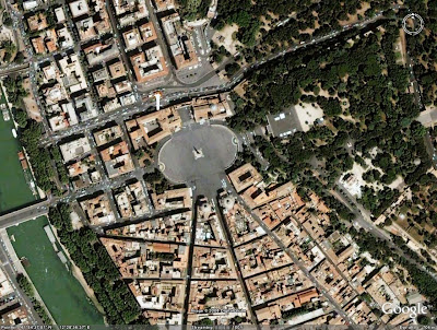
Piazza del Popolo, Rome, Italy

Coordinates: 41° 54' 38" N, 12° 28' 35" E. Find With Google Earth.

Piazza del Popolo, Rome, Italy

The Piazza del Popolo is a square in Rome. The name in modern Italian literally means "piazza of the people", but historically it derives from the poplars (populus in Latin, pioppo in Italian) after which the church of Santa Maria del Popolo, in the northeast corner of the piazza, takes its name.

The Piazza lies inside the northern gate in the Aurelian Walls, once the Porta Flaminia of ancient Rome, and now called Porta del Popolo. This was the starting point of the Via Flaminia, the road to Ariminum (modern Rimini) and the most important route to the north. At the same time, before the age of railroads, it was the traveller's first view of Rome upon arrival. For centuries, the Piazza del Popolo was a place for public executions, the last of which took place in 1826. Learn more...

Piazza Navona, Rome, Italy

Coordinates: 41° 53' 56" N, 12° 28' 23" E. Find With Google Earth.

Piazza Navona, Rome, Italy

Piazza Navona is a square in Rome, Italy. The piazza follows the plan of an ancient Roman circus, the 1st century Stadium of Domitian, where the Romans came to watch the agones ("games"): It was known as 'Circus Agonalis' (competition arena). It is believed that over time the name changed to 'in agone' to 'navone' and eventually to 'navona'.

Defined as a square in the last years of 15th century, when the city market was transferred here from the Campidoglio, Piazza Navona is now the pride of Baroque Rome. It has sculptural and architectural creations: by Gian Lorenzo Bernini, the famous Fontana dei Quattro Fiumi (Fountain of the Four Rivers, 1651) in the center; by Francesco Borromini and Girolamo Rainaldi, the church of Sant'Agnese in Agone; and by Pietro da Cortona, who painted the gallery in the Pamphilj palace. Learn more...

10 April 2008

Quirinal Palace, Rome, Italy

Coordinates: 41° 54' 0" N, 12° 29' 12.85" E. Find With Google Earth.

Quirinal Palace, Rome, Italy

The Quirinal Palace (known in Italian as the Palazzo del Quirinale or simply the Quirinale) is the official residence of the President of the Italian Republic upon the Quirinal Hill, the tallest of the seven hills of Rome.

The palace, located on the Via del Quirinale and facing onto the Piazza del Quirinale, was built in 1573 by Pope Gregory XIII as a papal summer residence. It was also used as the location for many papal conclaves. It served as a papal residence and housed the central offices responsible for the civil government of the Papal States until 1870. In September, 1870, what was left of the Papal States was overthrown. About five months later, in 1871, Rome became the capital of the new Kingdom of Italy. The palace was occupied during the invasion of Rome and became the official royal residence of the Kings of Italy, though in reality some monarchs, notably King Victor Emmanuel III (reigned 1900-1946) actually lived in a private residence elsewhere, the Quirinale being used simply as an office and for state functions. The monarchy was abolished in 1946 and the Palace became the official residence and workplace for the Presidents of the Italian Republic. Learn more...

09 April 2008

Palazzo Montecitorio, Rome, Italy

Coordinates: 41° 54' 5" N, 12° 28' 43" E. Find With Google Earth.

Palazzo Montecitorio, Rome, Italy

The Palazzo Montecitorio is a palace in Rome, which is currently the seat of the Italian Chamber of Deputies.

The building was originally designed by Gian Lorenzo Bernini for the young Cardinal Ludovisi, nephew of Pope Gregory XV. However, with the death of Gregory XV by 1623, work stopped, and was not restarted until the papacy of pope Innocent X, when it was completed by the architect Carlo Fontana, who modified Bernini's plan with the addition of a bell gable above the main entrance. Learn more...

07 April 2008

Monument to Vittorio Emanuele II, Rome, Italy

Coordinates: 41° 53' 40.55" N, 12° 28' 59.13" E. Find With Google Earth.

Monument to Vittorio Emanuele II, Rome, Italy

The Monumento Nazionale a Vittorio Emanuele II (National Monument of Victor Emmanuel II) or Altare della Patria (Altar of the Fatherland) or "Il Vittoriano" is a monument to honour Victor Emmanuel, the first king of a unified Italy. It is located in Rome, Italy. It occupies a site between the Piazza Venezia and the Capitoline Hill. The monument was designed by Giuseppe Sacconi in 1895; sculpture for it was parceled out to established sculptors all over Italy. It was inaugurated in 1911 and completed in 1935. Learn more...

Basilica of Saint Paul Outside the Walls, Rome, Italy

Coordinates: 41° 51' 31" N, 12° 28' 38" E. Find With Google Earth.

Basilica of Saint Paul Outside the Walls, Rome, Italy

Basilica di San Paolo fuori le Mura — known in English as the Basilica of St Paul Outside the Walls or St Paul-without-the-Walls — is one of four churches considered to be the great ancient basilicas of Rome. The Roman Catholic Church counts among them St. John Lateran, St. Mary Major, and St. Peter's. Cardinal Andrea Cordero Lanza di Montezemolo, named in 2005, is the current archpriest of this basilica. Learn more...