Google
 

31 August 2008

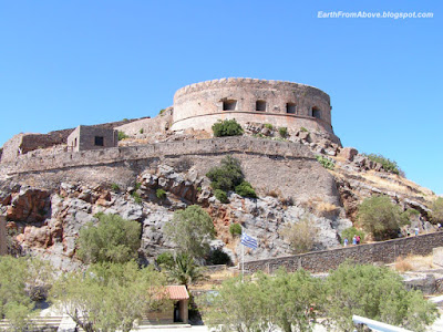
The Island of Spinalonga, Greece

Coordinates: 35° 16' 20" N, 25° 44' 55" E. Find With Google Earth.

The Island of Spinalonga from above

The island of Spinalonga (official name: Kalidon) is located at the eastern section of Crete, near the town of Elounda. The name of the island, Spinalonga, is Venetian, meaning "long thorn", and has roots in the period of Venetian occupation.

The Island of Spinalonga

The Spinalonga fortress was built by the Venetians in XVIth century. In 1579, the General Previsor of Crete Luca Michiel put the foundation stone of the fortifications. Following the Turkish occupation of Crete in 1669, only the fortresses of Gramvousa , Souda and Spinalonga remained in Venetian hands. The Venetians kept control of the island until the Ottoman Empire took possession of it in 1715.

The Spinalonga Fortress

The island was subsequently used as a leper colony, from 1903 to 1957. It is notable for being one of the last active leper colonies in Europe.

Today, the unoccupied island is one of the main tourist attractions in Crete. In addition to the abandoned leper colony and the fortress, Spinalonga is known for its small pebble beaches. The island can easily be accessed from Elounda and Agios Nikolaos. Tourist boats depart from both towns on a daily basis. Learn more...

28 August 2008

Lake Voulismeni, Agios Nikolaos, Crete, Greece

Coordinates: 35° 11' 26" N, 25° 43' 2" E. Find With Google Earth.

Lake Voulismeni from Above, Agios Nikolaos, Crete, Greece

Lake Voulismeni (Limni Voulismeni) is a former sweetwater small lake, later connected to the sea, located at the centre of the town of Agios Nikolaos on the Greek island of Crete It has a circular shape of a diameter of 137 m and depth 64 m. The locals refer to it as just "the lake". The lake connects to the harbour of the town by a channel dug in 1870. A panoramic view of the lake can be seen from a small park situated above it.

According to legend, the goddess Athena bathed in it. Every year at midnight turning to Orthodox Christian Easter day, the majority of the population of the town gathers around the lake to celebrate with fireworks, and firecrackers thrown by the people attending that highlight event.

It was reported that the German army during their withdrawal from the area at WW2, disposed parts of their weaponry and/or vehicles into the deep lake.

A local urban legend has it that the lake is bottomless. That notion is potentially based on its impressively disproportional high depth compared to its width or/and on locals noticing disturbances at the surface or also the level of the water during the Santorini (Thera) earthquake of 1956. Because of the latter, many assume a possible geological relation of the two locations, but this claim has not been substantiated by known scientific surveys to date.

Source: en.wikipedia.org.

Lake Voulismeni, Agios Nikolaos, Crete, Greece

27 August 2008

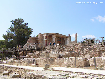
Knossos, Crete, Greece

Coordinates: 35° 17' 52.66" N, 25° 9' 47.36" E. Find With Google Earth.

Ruins of the Minoan palace at Knossos, Crete, Greece

Knossos (alternative spellings Knossus, Cnossus, Gnossus), is the largest Bronze Age archaeological site on Crete and probably the ceremonial and political center of the Minoan civilization and culture. It is also a tourist destination today, as it is near the main city of Heraklion and has been substantially, if imaginatively "restored", making the site more comprehensible to the visitor than a field of unmarked ruins.

The city of Knossos remained important through the Classical and Roman periods, but its population shifted to the new town of Handaq (modern Heraklion) during the 9th century AD. By the 13th century, it was called Makryteikhos 'Long Wall'; the bishops of Gortyn continued to call themselves Bishops of Knossos until the 19th century.[1] Today, the name is used only for the archaeological site situated in the suburbs of Heraklion. Learn more...

Ruins of the Minoan palace at Knossos, Crete, Greece

Bastion A at the North Entrance, the Minoan palace at Knossos, Crete, Greece

Ruins of the Minoan palace at Knossos, Crete, Greece

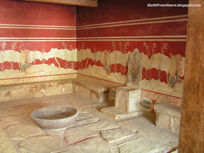
Throne Room, the Minoan palace at Knossos, Crete, Greece

Cathedral of St. Minas, Heraklion, Crete, Greece

Coordinates: 35° 20' 15.69" N, 25° 7' 52.01" E.


Cathedral of St. Minas, Heraklion, Crete, Greece

The Cathedral and of Saint Minas is the large and impressive church, situated on Saint Catherine square, in the town of Heraklion. It is one of the largest cathedrals in Greece.

Cathedral of St. Minas, Heraklion, Crete, Greece

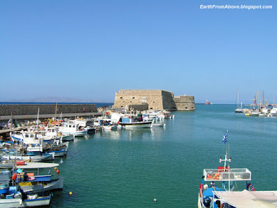
Venetian Medieval Fortress Rocca al Mare at the Harbour of Heraklion, Crete, Greece

Coordinates: 35° 20' 0" N, 25° 8' 0" E. Find With Google Earth.

Venetian Medieval Fortress Rocca al Mare at the Harbour of Heraklion, Crete, Greece

Heraklion or Iraklion is the largest city and capital of Crete. It is also the fourth largest city in Greece. For centuries Heraklion was known as Candia.

The biggest monument of the city is the Venetian medieval fortress Rocca al Mare (also known as Koules, Turkish for "tower") located at the port. Learn more...

Venetian Medieval Fortress Rocca al Mare at the Harbour of Heraklion, Crete, Greece

Venetian Medieval Fortress Rocca al Mare at the Harbour of Heraklion, Crete, Greece