Coordinates: 36° 25' 12" N, 25° 25' 54" E. Find With Google Earth.
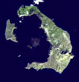
Santorini (Greek: Σαντορίνη) is a small, circular archipelago of volcanic islands located in the southern Aegean Sea, about 200 km (120 mi) southeast from Greece's mainland.
The name Santorini was given to it by the Latin empire in the thirteenth century, and is a reference to Saint Irene. Before then it was known as Kallístē (Καλλίστη, "the most beautiful one"), Strongýlē (Στρογγύλη, "the circular one"), or Thēra (Thira, Greek Θήρα [ˈθira]).
Santorini is essentially what remains of an enormous volcanic explosion, destroying the earliest settlements on what was formerly a single island, and leading to the creation of the current geological caldera.
It is the most active volcanic centre in the South Aegean Volcanic Arc, though what remains today is chiefly a water-filled caldera.
The island is the site of one of the largest volcanic eruptions in recorded history: the Minoan eruption (sometimes called the Thera eruption), which occurred some 3,600 years ago at the height of the Minoan civilization. The eruption left a large caldera surrounded by volcanic ash deposits hundreds of feet deep and may have led indirectly to the collapse of the Minoan civilization on the island of Crete, 110 km (68 mi) to the south, through the creation of a gigantic tsunami. Another popular theory holds that the Thera eruption is the source of the legend of Atlantis. Learn more...


